 Accueil Accueil
Notice
Histoire
Rôle(s)
Catégories
Liens
GpsPasSion
Versions
Bibliographie
Gargantua
Les Fées
|

 France - Allée couverte du Haut Bodel [ALHAUT] France - Allée couverte du Haut Bodel [ALHAUT]
|
Les 30 sites les plus proches :
| Distance | | ID Site | Photo | Description | Commune
(Département) | Ville proche |
|---|
|
| 0 Km | | ALHAUT 0 | | Allée couverte du Haut Bodel
| Caro
(Morbihan) | Redon |
| 0,1 Km |  | DRBODE-- | | Stèle de Bodel
| Caro
(Morbihan) | Redon |
| 0,2 Km |  | MHBODE*3 | 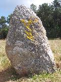 | Menhir du Bodel
| Caro
(Morbihan) | Redon |
| 1,7 Km |  | ALLOBO 5 | 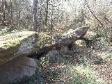 | Allée couverte de Lobo
Haut-Pinel | Caro
(Morbihan) | Redon |
| 2,7 Km |  | ALGRA1*3 | 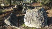 | Allée couverte du Grand-Village
| Caro
(Morbihan) | Redon |
| 3,2 Km |  | ALGRA2 X | | Allée couverte du Grand-Village Ouest
| Caro
(Morbihan) | Redon |
| 3,7 Km |  | MHDIGO*4 | 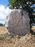 | Menhir de Digoit
Roche Piquée | Ruffiac
(Morbihan) | Redon |
| 4,7 Km |  | MADEVA-3 |  | Alignement d'Evas
| Saint Laurent sur Oust
(Morbihan) | Redon |
| 4,8 Km |  | ALGAJA-2 | 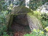 | Allée couverte de La Gajal
| Caro
(Morbihan) | Redon |
| 5,2 Km |  | MHGRAG 0 | | Menhir du Grass
| Ruffiac
(Morbihan) | Redon |
| 5,3 Km |  | ALROCH 2 |  | Allée couverte dite la Roche des Fées
La Coudraie | Augan
(Morbihan) | Redon |
| 5,3 Km |  | MHTROB*1 | 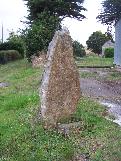 | Menhir de Trobert
| Réminiac
(Morbihan) | Redon |
| 5,4 Km | | MHSA26*4 | 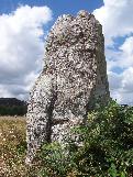 | Menhir du Champ Rullé
Cimetière | Saint Laurent sur Oust
(Morbihan) | Redon |
| 5,8 Km | | MHPIPR*4 |  | Menhir du Piprais
| Monterrein
(Morbihan) | Redon |
| 6 Km | | MHMAIS*4 | 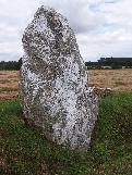 | Menhir dit Maison-Neuve
| Monterrein
(Morbihan) | Redon |
| 6,2 Km | | DLMADR-2 | 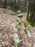 | Dolmen de Madry
| Tréal
(Morbihan) | Redon |
| 6,4 Km | | ALPRAY X | | Allée couverte du Pray
| Caro
(Morbihan) | Redon |
| 6,5 Km |  | CVHAUT-0 | | Calvaire de la Haute-Touche
| Monterrein
(Morbihan) | Redon |
| 6,7 Km |  | EGMAD1-3 | 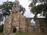 | Chapelle de la Madeleine
| Malestroit
(Morbihan) | Redon |
| 6,7 Km | | MHBEA1*3 | 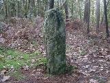 | Menhir de Beaumont
| Saint Laurent sur Oust
(Morbihan) | Redon |
| 6,7 Km |  | ALBEAU*2 | .jpg) | Allée couverte de Beaumont
Courtil aux Fées | Saint Laurent sur Oust
(Morbihan) | Redon |
| 6,7 Km |  | FOCOU0*3 | | Fort dit le Courtil aux Fées
| Ruffiac
(Morbihan) | Redon |
| 6,8 Km | | CVGREC-0 | | Calvaire du Château de la Grée de Callac
| Augan
(Morbihan) | Redon |
| 6,9 Km | | CVSAI4-0 | | Calvaire Saint-Marc
| Pleucadeuc
(Morbihan) | Redon |
| 7,2 Km |  | EGSA15-4 |  | Eglise Saint-Gilles
| Malestroit
(Morbihan) | Redon |
| 7,5 Km |  | DLMAI6*4 | 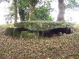 | Dolmen dit Maison-Trouvée
La Ville-au-Voyer ; Maison-Trouée | Chapelle Caro
(Morbihan) | Redon |
| 7,7 Km |  | MAPASG-1 |  | Alignement dit le Pas de Gargantua
| Chapelle Caro
(Morbihan) | Redon |
| 7,8 Km | | ALMAI0 0 | | Allée couverte du Bignon
| Chapelle Caro
(Morbihan) | Redon |
| 7,9 Km | | ALPASG+3 | 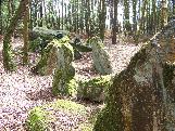 | Allée couverte dite la Maison du Diable
Lande de La Chapelle | Chapelle Caro
(Morbihan) | Redon |
| 7,9 Km |  | ALDEAU-0 | | Allée couverte dite Château d'Eau
| Monteneuf
(Morbihan) | Redon |
| 7,9 Km |  | ALCHAP 1 |  | Allée couverte du Chaperon Rouge
| Monteneuf
(Morbihan) | Redon |
|
|
| © 2004-2024 T4T35 - Version du 3 décembre 2020 22:31 - Email : T4T35 |
|

 Belgique
 Ecosse
 France
 Irlande
 Pays de Galles