 Accueil Accueil
Notice
Histoire
Rôle(s)
Catégories
Liens
GpsPasSion
Versions
Bibliographie
Gargantua
Les Fées
|

 France - Dolmen de Marcilhac [DLMARM] France - Dolmen de Marcilhac [DLMARM]
|
Les 30 sites les plus proches :
| Distance | | ID Site | Photo | Description | Commune
(Département) | Ville proche |
|---|
|
| 0 Km | | DLMARM 2 | | Dolmen de Marcilhac
| Lamothe Fénelon
(Lot) | Gourdon |
| 2,8 Km |  | DLGREZ 0 | | Dolmen de Grezelade (C)
| Lanzac
(Lot) | Gourdon |
| 5,6 Km |  | DLCART-2 |  | Dolmen de Cieurac
Cartayroux | Lanzac
(Lot) | Gourdon |
| 6,6 Km |  | ABBTIM-0 | | Bâtiments conventuels de Sainte-Marie
| Souillac
(Lot) | Gourdon |
| 7,7 Km |  | MHMAYR*3 | 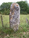 | Menhir de Mayrac
| Mayrac
(Lot) | Gourdon |
| 8,1 Km |  | GTABR5-0 | | Abris préhistoriques de Pinsac
| Pinsac
(Lot) | Gourdon |
| 8,8 Km |  | DLLAVA+3 | 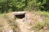 | Dolmen de Laval
| Souillac
(Lot) | Sarlat la Canéda |
| 9,2 Km |  | DLRIG0+4 | .jpg) | Dolmen de Rigou
| Saint Projet
(Lot) | Gourdon |
| 9,2 Km | | MHMAY0*3 | 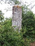 | Menhir de la Pierre Plantée du Pigeon-Haut
Mayrac (B) | Mayrac
(Lot) | Gourdon |
| 9,6 Km | | DLTOMH-2 | .jpg) | Dolmen dit le Tombeau du Gaulois
Pech Grand | Saint Sozy
(Lot) | Gourdon |
| 10,5 Km | | DLPECO 0 | | Dolmen du Pech de Gourbières (B)
| Rocamadour
(Lot) | Gourdon |
| 10,5 Km |  | DLPECN-0 | | Dolmen du Pech de Gourbières (A)
| Rocamadour
(Lot) | Gourdon |
| 10,7 Km | | DLDIVI 0 | | Dolmens de Divinaudes
| Meyronne
(Lot) | Gourdon |
| 11 Km | | GTCOU0-0 | | Grotte de Cougnac
| Payrignac
(Lot) | Gourdon |
| 12 Km |  | LHPEYR+2 | 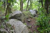 | Cromlech de Peyrebrune
| Saint Projet
(Lot) | Gourdon |
| 12,4 Km | | DLPE44 0 | | Dolmen de Peyrebrune
| Saint Projet
(Lot) | Gourdon |
| 13,2 Km | ") | TPLA16X0 | 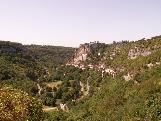 | Lanterne des Morts de Rocamadour
| Rocamadour
(Lot) | Gourdon |
| 13,3 Km | | DLPLAC+3 | 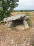 | Dolmen de Magès
| Rocamadour
(Lot) | Gourdon |
| 13,5 Km | | GTMERV-0 | | Grotte des Merveilles
| Rocamadour
(Lot) | Gourdon |
| 13,7 Km | | DLPLAV 0 | | Dolmen de Pélasse
| Montvalent
(Lot) | Gourdon |
| 13,9 Km | | DLCLO0+3 | | Dolmen des Cloups
| Ginouillac
(Lot) | Gourdon |
| 14,7 Km | | DLPLAP-0 | | Dolmen des Placels
| Montvalent
(Lot) | Gourdon |
| 15 Km |  | DLLIAD-1 |  | Dolmen de Liade
| Montvalent
(Lot) | Gourdon |
| 15,1 Km | | DLFOSS+3 | .jpg) | Dolmen des Fosses
| Soucirac
(Lot) | Gourdon |
| 15,2 Km |  | DLPLAU-3 | .jpg) | Dolmen des Plantoux
de la Rue | Rocamadour
(Lot) | Gourdon |
| 16,1 Km |  | DLBAR6+2 | 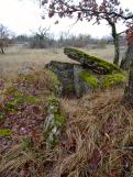 | Dolmen de Barthe Soubronne
| Montvalent
(Lot) | Gourdon |
| 16,2 Km | | DLBARF-0 | | Dolmen de Barrade
| Montvalent
(Lot) | Gourdon |
| 16,2 Km |  | FOLAZO-0 | | Oppidum de l'Azoul
| Rocamadour
(Lot) | Gourdon |
| 16,3 Km |  | EGSAJ1-4 | 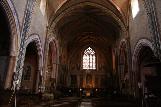 | Eglise Saint-Maur
| Martel
(Lot) | Brive la Gaillarde |
| 16,7 Km |  | DLPANO 3 | | Dolmen dit la Pierre Levée de la Pannonie
Magès | Rocamadour
(Lot) | Gourdon |
| 17,2 Km | | DLCO20-0 | | Dolmen de Costeraste
| Gourdon
(Lot) | Gourdon |
|
|
| © 2004-2024 T4T35 - Version du 3 décembre 2020 22:31 - Email : T4T35 |
|

 Belgique
 Ecosse
 France
 Irlande
 Pays de Galles