 Accueil Accueil
Notice
Histoire
Rôle(s)
Catégories
Liens
GpsPasSion
Versions
Bibliographie
Gargantua
Les Fées
|

 France - Dolmen de Grioudas (E) [DLGRI2] France - Dolmen de Grioudas (E) [DLGRI2]
|
Les 30 sites les plus proches :
| Distance | | ID Site | Photo | Description | Commune
(Département) | Ville proche |
|---|
|
| 0 Km | | DLGRI2+2 | 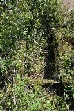 | Dolmen de Grioudas (E)
| Bozouls
(Aveyron) | Rodez |
| 0,3 Km |  | DLGRI1+1 | 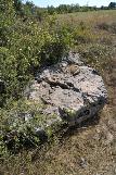 | Dolmen de Grioudas (B)
| Montrozier
(Aveyron) | Rodez |
| 0,7 Km | | DLGRI0+2 |  | Dolmen de Grioudas (F)
| Bozouls
(Aveyron) | Rodez |
| 0,8 Km | | DLBERG+2 | 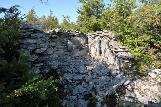 | Dolmen de la Bergerie (C)
| Montrozier
(Aveyron) | Rodez |
| 0,9 Km | | DLGRIO+2 |  | Dolmen de Grioudas (C)
| Bozouls
(Aveyron) | Rodez |
| 0,9 Km | | DLDALB+2 | 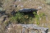 | Dolmen de la Bergerie (B)
Albory | Montrozier
(Aveyron) | Rodez |
| 1,1 Km | | DLDAL0+2 | 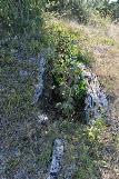 | Dolmen de la Bergerie (A)
Albory | Montrozier
(Aveyron) | Rodez |
| 1,2 Km | | DLDABO+1 | 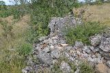 | Dolmen d''Aboul
| Bozouls
(Aveyron) | Rodez |
| 1,8 Km | | DLVAY4+2 | 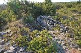 | Dolmen des Vayssettes (D)
| Montrozier
(Aveyron) | Rodez |
| 2,3 Km | | DLVAY2+2 | 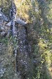 | Dolmen des Vayssettes (C)
| Montrozier
(Aveyron) | Rodez |
| 2,3 Km | | DLVAY1+1 | 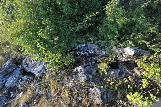 | Dolmen des Vayssettes (B)
| Montrozier
(Aveyron) | Rodez |
| 2,5 Km | | DLGAGE+2 |  | Dolmen de Gages-le-Haut
| Montrozier
(Aveyron) | Rodez |
| 2,7 Km | | DLVAY0+1 | 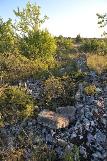 | Dolmen des Vayssettes (A)
| Montrozier
(Aveyron) | Rodez |
| 2,8 Km |  | DLVAY5 0 | | Dolmen des Vayssettes (F)
| Bozouls
(Aveyron) | Rodez |
| 3,6 Km |  | MUROUE 4 | | Musée du Rouergue
| Montrozier
(Aveyron) | Rodez |
| 4,1 Km | | DLSEV0+1 |  | Dolmen de Seveyrac
| Bozouls
(Aveyron) | Rodez |
| 4,2 Km | | DLCRES+2 | 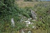 | Dolmen de Crespiac (A)
| Bozouls
(Aveyron) | Rodez |
| 4,3 Km | | DLCOMT+2 |  | Dolmen de Campeyroux
Comtal | Sébazac Concourès
(Aveyron) | Rodez |
| 4,3 Km |  | DLCAYS-2 | 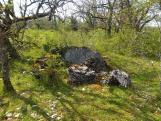 | Dolmen de Cayssac (A)
| Loubière
(Aveyron) | Rodez |
| 4,8 Km | | DLVIG0+1 | 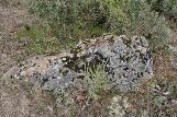 | Dolmen de la Viguerie
| Bozouls
(Aveyron) | Rodez |
| 5,4 Km |  | EGSAII-4 |  | Eglise Sainte-Fauste
| Bozouls
(Aveyron) | Rodez |
| 5,7 Km |  | TMCAST X | | Tumulus des Castelets (A)
| Loubière
(Aveyron) | Rodez |
| 5,7 Km |  | CXBANC+4 | 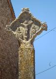 | Croix de Banc
| Bertholène
(Aveyron) | Rodez |
| 6,1 Km |  | EGDANG-0 | | Eglise d'Anglars
| Bertholène
(Aveyron) | Rodez |
| 6,4 Km |  | DLBEZO+3 | 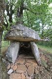 | Dolmen de Bezonnes (B)
Costes-Basses | Rodelle
(Aveyron) | Rodez |
| 6,4 Km |  | CHBERT-4 | 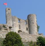 | Château de Bertholène
| Bertholène
(Aveyron) | Rodez |
| 6,8 Km |  | DLMADI X | | Dolmen de Madinhac (B)
| Bozouls
(Aveyron) | Rodez |
| 6,8 Km | | DLFON7+2 | .jpg) | Dolmen de la Fontaine-aux-Chiens
Madinhac (A); Coudournac | Bozouls
(Aveyron) | Rodez |
| 7 Km |  | DLBEZ1 1 |  | Dolmen de Bezonnes (C)
Tombeau des Anglais | Rodelle
(Aveyron) | Rodez |
| 7,2 Km | | DLDAGE*3 | 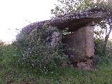 | Dolmen d'Agen d'Aveyron
Bouissou | Agen d'Aveyron
(Aveyron) | Rodez |
| 7,4 Km | | DLMAD2+1 |  | Dolmen de Madinhac (C)
| Bozouls
(Aveyron) | Rodez |
|
|
| © 2004-2024 T4T35 - Version du 3 décembre 2020 22:31 - Email : T4T35 |
|

 Belgique
 Ecosse
 France
 Irlande
 Pays de Galles